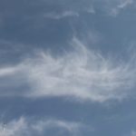
![津波直後の大洗港・空撮[震災当日]](https://wisdombank.net/wp-content/uploads/2022/12/unnamed-file.jpg)
Oarai Port just after the Tsunami, aerial shot (Day of the earthquake)
The Japanese text is followed by an English translation.
津波に襲われた直後の大洗町(震災当日 : 午後5時すぎ)。ヘリからの空撮映像。
大洗港付近を中心に撮影。
県道106号線を、港から内陸に向かい、海水が約1kmにもわたり、ゆっくりさかのぼっている様子が見える。港付近は、いたるところが冠水し、マリーナの船置場も小型船が散乱している。
ビーチ付近から沖に目を転じると、海上にいくつも大きな渦が発生し、海面を白く泡立てている。不規則な潮流の合間に浮かび、今にも大渦に吸い込まれそうな船もある。
フェリータミナル近くは、多くのコンテナがガレキのように散らばり、魚市場付近では、小型の漁船やボートが、転覆したり、埠頭に乗り上げたり、さらに県道2号線沿いも、何台ものトラックが道路に置き去りにされ、積荷がばらまかれたような状態も垣間見える。
午後5時半近くになり、ようやく海上の渦は消えていった。
Oarai town just after the Tsunami attack. (Day of the earthquake: After 5 p.m.) Areas around Oarai Port were recorded from an aerial shot by helicopter. One can observe the sea water slowly going upstream to inland, about 1km from the port up prefectural road #106. Areas around the port have been flooded and small boats scatter around the marina's boat anchorage area. Looking offshore from the beach area, a number of large whirlpools have formed, creating a white bubbly surface on the water. There are boats that could be swallowed by the whirlpool any minute, floating between irregular waves. Near the ferry terminal, many containers scatter like debris. Around the fish market, smaller fishing boats and other boats have been overturned or driven up the wharf. Along prefectural road #2, many trucks have been abandoned on the road, and scattered cargo can be witnessed around them. At half past five, the whirlpool on top the sea water has finally disappeared.
(Reporting from helicopter by Fuji TV reporter Ayaka Shimada)
地図を見る